


 |
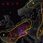
https://preview.redd.it/hdrc9xzsbe9d1.png?width=517&format=png&auto=webp&s=d54d01f4dd8481ddee5d7346b4a7b657f3cde94a DISCUSSION ***A regional outbreak of severe thunderstorms is forecast with very large to destructive hail, damaging winds and extreme rainfall, including a regionally increased risk of severe tornadoes*** … E-France to Germany and NW Switzerland … A weakening but still strong low amplitude wave approaches from the SW during the day. This is accompanied by an 80kt high jet with a diffuse and divergent exit area covering a very unstable warm sector, although this jet weakens before entering Germany. This wave induces constant low pressure over most of France into W-Germany during the day, which remains quite diffuse and results in a SW-NE aligned broad low pressure area probably with an embedded surface circulation over E-France. This low pressure merges with another structuring low pressure over SE-Germany, which shifts Nwards during the night and both merge into one dominant LL depression over N/NE-Germany towards the end of this forecast period. The warm sector airmass has unusually moist BL conditions with BL mixing ratios in the 12-15 g/kg range with even higher peaks towards the upper Rhine, translating to dew points in the upper teens to lower twenties. Some locations along the northward moving warm front may see a Td increase of over 10K within 12-15 hours. A northward spreading EML with mid-range lapse rates of over 7K/km interacts with this warm sector airmass to produce afternoon MUCAPE values in the 2000-3000 J/kg range with local peaks of 4000-5000 J/kg possible at the tops of regions with maximized BL humidity (e.g. upper Rhine). Strong WAA (partly reinforced by Alpine downslope component) pushes 850 hPa temperature into the 20-26 C range, causing modest capping of most of the German warm sector during the day, while cap weakens towards CNTRL Germany and France. Also a drying/mixing BL N from the Alps helps with capping issues. During the afternoon, a few thunderstorms may develop along the warm front, as the ongoing WAA interacts with the more complex orography and as a vorticity lobe/shortwave crosses the warm front towards the east/northeast, while CAMs are almost now showing cap (as strong diabatic heating verifies!). At the same time (from early afternoon hours) the focus shifts to SE in EE France and W/NW Switzerland. A broad belt of 15-20 m/s DLS and similar shear values in the lower 3 km overlap with abundant CAPE, so in combination with the incoming forcing from the SW and diurnal heating, scattered severe thunderstorms erupt. Even with dusty cloud cover, only temporary diabatic heating should be sufficient for CI as surface temperatures rise into the upper 20s. The amount of CAPE and incoming forcing should cause scattered to widespread CI. Each maturing updraft has a long lifespan and plenty of shear force to work with. A mix of long-lived supercells and severe bow echoes are forecast with a range of severe and extremely severe hazards, including very large to giant hail, excessive rain, severe/damaging parts of high winds and a few tornadoes, including a strong one. (especially in the case of reduced LCLs due to previous convection). Widespread CI can sometimes cause erratic storm interactions with a rapid tendency to grow clusters. Colliding convection can bring the risk of local life-threatening flash flooding! As we get deeper into the evening hours, the focus shifts from a more discrete storm mode to a clustered/semi-discrete one. A mix of long-lived tail-end supercells, embedded arc echoes and a growing severe MCS should cause enough (extreme) reports to trigger a targeted upgrade to a level 3 from NW-Switzerland to E-France and towards SW/CNTRL-Germany to justify. If we get a severe MCS as we enter SW Germany, a long band of damaging hail/heavy winds could develop. The highest confidence for such an event is a potential MCS tracking along the French/Swiss border to the Upper Rhine, where the most extreme CAPE awaits convection. Mature convection is likely to start to outrun the surface-based CAPE plume somewhere over CNTRL Germany before moving along the sloping frontal zone towards NE Germany overnight. Although the severe risk decreases, hail and heavy rainfall remain a persistent threat. We would not be surprised to see a persistent severe risk in Saxony/NW Czech Republic as the MCS builds to the SE of the CAPE plume. All types of hazards will continue to exist with this activity until the end of the forecast period, including severe wind gusts should we see enough BL modification for surface-based activity. We have broadened level 2 well into Bavaria to account for CI more E in the reservoir of rich CAPE. If this scenario verifies, the risk changes to very large hailstorms and severe eruptions with more increased convection and thick MUCAPE profiles over the canopy. Another concern is emerging from CNTRL France to Belgium and NW Germany from the afternoon into the night as the risk extends to the northeast. https://www.estofex.org/ submitted by /u/grxxl |


