


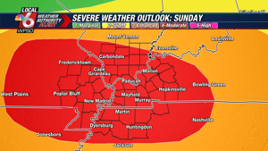

The National Weather Service in Paducah has issued a

* Severe Thunderstorm Warning for...
Central Pulaski County in southern Illinois...
Southern Massac County in southern Illinois...
Southeastern Alexander County in southern Illinois...
Carlisle County in western Kentucky...
Northwestern Hickman County in western Kentucky...
Ballard County in western Kentucky...
McCracken County in western Kentucky...
Northwestern Graves County in western Kentucky...
Mississippi County in southeastern Missouri...
Northeastern New Madrid County in southeastern Missouri...

* Until 945 PM CDT.

* At 841 PM CDT, severe thunderstorms were located along a line
extending from near Karnak to near Charleston to near Bernie,
moving southeast at 40 mph.

HAZARD...60 mph wind gusts and quarter size hail.

SOURCE...Radar indicated.

IMPACT...Hail damage to vehicles is expected. Expect wind damage
to roofs, siding, and trees.

* Locations impacted include...
Paducah, Metropolis, Charleston, East Prairie, Cairo, La Center,
Bardwell, Wickliffe, Towosahgy State Historic Site, Reidland, Lone
Oak, Brookport, Bertrand, Mounds, Barlow, Matthews, Mound City,
Wyatt, Anniston, and Barkley Regional Airport.

This includes the following highways...
Interstate 24 in Kentucky between Mile Markers 1 and 17.
Interstate 24 in Illinois between Mile Markers 37 and 38.
Interstate 57 in Illinois between Mile Markers 1 and 10.
Interstate 57 in Missouri between Mile Markers 3 and 21.
Interstate 55 between Mile Markers 50 and 64.

PRECAUTIONARY/PREPAREDNESS ACTIONS...

For your protection move to an interior room on the lowest floor of a
building.

A Tornado Watch remains in effect until 1100 PM CDT for southern
Illinois...western Kentucky...and southeastern Missouri.

&&


HAIL THREAT...RADAR INDICATED;
MAX HAIL SIZE...1.00 IN;
WIND THREAT...RADAR INDICATED;
MAX WIND GUST...60 MPH
TORNADO WATCH 320 REMAINS VALID UNTIL 11 PM CDT THIS EVENING FOR
THE FOLLOWING AREAS

IN ILLINOIS THIS WATCH INCLUDES 13 COUNTIES

IN SOUTHERN ILLINOIS

ALEXANDER             FRANKLIN              HAMILTON
JACKSON               JEFFERSON             JOHNSON
MASSAC                PERRY                 POPE
PULASKI               SALINE                UNION
WILLIAMSON

IN KENTUCKY THIS WATCH INCLUDES 9 COUNTIES

IN WESTERN KENTUCKY

BALLARD               CALLOWAY              CARLISLE
FULTON                GRAVES                HICKMAN
LIVINGSTON            MARSHALL              MCCRACKEN

IN MISSOURI THIS WATCH INCLUDES 11 COUNTIES

IN SOUTHEAST MISSOURI

BOLLINGER             BUTLER                CAPE GIRARDEAU
CARTER                MISSISSIPPI           NEW MADRID
PERRY                 RIPLEY                SCOTT
STODDARD              WAYNE

THIS INCLUDES THE CITIES OF BARDWELL, BENTON, BLOOMFIELD, CAIRO,
CAPE GIRARDEAU, CARBONDALE, CHARLESTON, CLINTON, DONIPHAN,
GOLCONDA, HARRISBURG, HERRIN, HICKMAN, JACKSON, JONESBORO,
MARBLE HILL, MAYFIELD, MCLEANSBORO, METROPOLIS, MOUND CITY,
MOUNT VERNON, MURPHYSBORO, MURRAY, NEW MADRID, PADUCAH,
PERRYVILLE, PIEDMONT, PINCKNEYVILLE, POPLAR BLUFF, SIKESTON,
SMITHLAND, VAN BUREN, VIENNA, WEST FRANKFORT, AND WICKLIFFE.
...FLOOD WATCH REMAINS IN EFFECT THROUGH MONDAY MORNING...

* WHAT...Flooding caused by excessive rainfall continues to be
possible.

* WHERE...Portions of southern Illinois, including the following
areas, Alexander, Edwards, Franklin, Gallatin, Hamilton, Hardin,
Jackson, Jefferson, Johnson, Massac, Perry IL, Pope, Pulaski,
Saline, Union, Wabash, Wayne IL, White and Williamson, southwest
Indiana, including the following areas, Gibson, Pike, Posey,
Spencer, Vanderburgh and Warrick, western Kentucky, including the
following areas, Ballard, Caldwell, Calloway, Carlisle, Christian,
Crittenden, Daviess, Fulton, Graves, Henderson, Hickman, Hopkins,
Livingston, Lyon, Marshall, McCracken, McLean, Muhlenberg, Todd,
Trigg, Union KY and Webster, and southeast Missouri, including the
following areas, Bollinger, Butler, Cape Girardeau, Carter,
Mississippi, New Madrid, Perry MO, Ripley, Scott, Stoddard and
Wayne MO.

* WHEN...Through Monday morning.

* IMPACTS...Excessive runoff may result in flooding of rivers,
creeks, streams, and other low-lying and flood-prone locations.

* ADDITIONAL DETAILS...
- Widespread rainfall amounts of 2 to 3 inches occurred this
morning, particularly focused across southeast Missouri,
western Kentucky, and far southern Illinois. Localized higher
amounts up to 5 inches were observed. Another round of very
heavy rain is expected with severe thunderstorms through this
evening. This likely will lead to additional rainfall amounts
of 1 to 3 inches, with localized higher amounts possible.
This will lead to a heightened flash flooding concern,
especially in those areas that already received flooding this
morning. Significant flash flooding is possible in some of
these locations this evening.
- http://www.weather.gov/safety/flood

PRECAUTIONARY/PREPAREDNESS ACTIONS...

You should monitor later forecasts and be alert for possible Flood
Warnings. Those living in areas prone to flooding should be prepared
to take action should flooding develop.

&&


