


") |
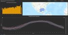
Hello all! I made something really cool that I wanted to share. It is a global dashboard for sea surface temperature. This dashboard is updated daily and displays average sea surface temperatures globally and for specific water bodies in both Celsius and Fahrenheit. SST data is provided by NOAA. This project is powered entirely through Python, ArcGIS Pro, and ArcGIS Online. With hundreds of lines of code using ten different libraries, along with hundreds of hours of development and processing, this was my biggest challenge yet. Take a look at the dashboard and vote or share if you find it helpful. 🙂 Link to Dashboard: https://geomapit.maps.arcgis.com/apps/dashboards/06572b4963c149489fc080c142707abe https://preview.redd.it/mmb0mc0vve0d1.png?width=2559&format=png&auto=webp&s=44b987bb8becc5684032565a606cb644722c6e9f This is version 1.0. Please give me your thoughts and feedback! submitted by /u/geomapit |


