

WHERE DO WE GO FROM HERE? REST OF WINTER OUTLOOK:
If you remember, in early fall 2022, I posted here betting my “house and car on one or two snow events in December.” Luckily that happened and I can keep my Jeep, LOL. All kidding aside, we are still in a La Nina winter pattern. Time for another long forecast in the ‘magic 8 ball’ of weather.
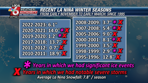
In case you forgot, the La Nina winter seasons are notorious for HEAT, SEVERE STORMS, and ICE STORMS/EVENTS here.
Check out the graph above this text of all La Nina winters since 1995. Each winter had a “notable severe weather event or outbreak” – that is, multiple tornadoes (3 or more) or a strong/deadly tornado (EF2+) or wind damage. (75+ MPH gust) episode. 6 out of 12 (50%) had an ice event.
Looking ahead at the data through February 2023, I think January 2023 will start out mild and wet/stormy from about January 10 to 14. Signals for a major cold snap, or two tamer ones in the second half of the month with a major winter event possible (more ice/mix, but TBA). But the month ends warmer than average. February 2023 also favors several (more than 3) days 60+ and a severe threat day, or two, given statistical analysis. While I can’t rule out another major snow event, the chances aren’t great.
I would like to add a few winter seasons that I have been watching behind the scenes at work since this fall. These are the winters of: 1999-2000, 2007-2008, 2010-2011 and last winter. These winters are all very similar to the Northern Hemisphere pattern we are in now, and emerged from late summer and fall. And also being in La Nina. Below are the results from the winter seasons in January and February. Note, most had a lot of warm spells, little or no snow, and an episode of severe weather.
January 2022: 3.7″ snow, 1 day 60°+, EF2 tornado Hopkinsville KY
February 2022: 1.5 inches of snow, 8 days of 60°+, EF0 tornado and a microburst
January 2011: 4.3″ of snow, 0 days 60°+
February 2011: 9.0″ snow, 8 days 60°+, tornado outbreak February 24/27
January 2008: 1.7″ snow, 5 days 60°+, several EF1/EF0 tornadoes
February 2008: 1.5 inches of snow, 6 days of 60°+, deadly tornadoes February 5
January 2000: 6.5 cm of snow, 7 days of 60°+, deadly tornado outbreak
February 2000: 0.7″ snow, 12 days 60°F, 4 days 70°+, 75MPH microburst
I’ll add two other “wildcard” winters that are similar to the current epic cold we just had in December 2022, although they get an * asterisk because those winters were El Nino ones and NOT La Nina ones. Here’s how the following January and February closed out those years. Interestingly enough, this fits with the story of La Nina’s winter analogues. The cold snap we just had was, for many, the worst in the Mid-South since the epic cold snap of 1989.
January 2005: 0 snow, 9 days 60°+
February 2005: 0 snow, 9 days 60°+
January 1990: 0.1″ of snow, 9 days 60°+
February 1990: 1.0″ measurable snow, 11 days 60°+
So time for my next prediction “bet” for you all. Combined between January and February 2023, we will have 10 or MORE days of 60°F (the historical average for all months of January and February combined is 10, since 1937). At least 1.5 inches of additional snow, and 1 day of severe weather. Can I be completely wrong after all those hours of research? Sure. Am I going to get lucky or am I really working on this? I hope so, but who knows. why i say meteorology is like golf, because once you think you have it figured out, it humbles you and you realize no one gets it.